Soil cavities are often caused by natural processes such as erosion, weathering, or landslides. They can also result from human activities such as mining, construction, or excavation. Regardless of their cause, these can weaken the ground and cause sinkholes or subsidence, damaging infrastructure and buildings.
Cavity mapping is an essential technique in geotechnical engineering for the identification and characterisation of voids, cavities, and other underground features that may influence the stability and safety of infrastructure projects.
Here are some of the significances of cavity mapping in geotechnical engineering:
- Identification of potential hazards: Identify the presence of underground spaces that may pose a risk to the stability of a structure. These spaces may include sinkholes, voids, and abandoned mines. By identifying potential hazards early, engineers can take appropriate measures to mitigate risks and prevent accidents.Methods,
- Understanding the subsurface: provides critical information on the subsurface, including soil types, rock formations, and geological features. This insight helps geotechnical engineers design safe and stable foundations that can withstand loads and environmental factors.
- Better project planning: With accurate cavity mapping data, engineers can create better project plans. This information can help determine the appropriate equipment, materials and techniques required for the project, as well as the potential risks and challenges. This will help prevent costly delays and ensure that the project is completed on schedule and within budget.
- Environmental protection: Identify and protect sensitive environmental areas such as wetlands, wildlife habitats, and groundwater resources. This information helps to minimise the negative impact of construction projects on the environment.
In order to map soil cavities, the following methods are used:
· Ground-penetrating radar – uses radio waves to detect changes in soil density or material.
· Electromagnetic surveys – uses electrical signals to detect changes in soil conductivity which can indicate the presence of cavities.
· Seismic methods – sends sound waves into the ground and measures the time and intensity of their reflections.
This allows professionals to create a map of the underground soil structure, identifying areas where cavities exist. Once soil cavities have been mapped, mitigating plans can be developed. Overall, cavity mapping is a crucial aspect of geotechnical engineering, and it helps to ensure that infrastructure and construction projects are safe, efficient, and environmentally responsible.
By identifying and assessing the risks posed by soil cavities, engineers and construction professionals can better plan infrastructure projects and property management, potentially avoiding costly damages or disasters. At SGES, we ensure all these anomalies are mapped accurately to provide the best geotech solutions for a better world.
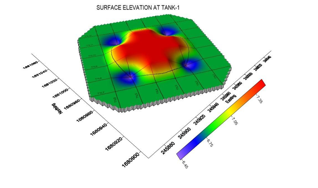
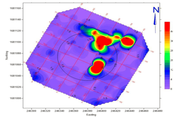
2D Electrical resisitivity mapping for detection of cavities for tank foundation of crude oil project-Yemen
Sharing an overview of Previous SGES project,
It was proposed to develop a crude oil Terminal project at RasIssa, Hodeidah, Yemen. #Geophysical survey indicated presence of two intermediate-scales, near surface highly fractured/cavernous structures (appx. 2.0m thick) at depth ranges between 5.75m and 6.5m below the existing natural ground level.